QGreenland 2026 Poster
A free GIS tool for QGreenland research
Rikki Held 
Trey Stafford
Twila Moon
Robyn Marowitz
Mariama Dryák-Vallies
Sarah McGhee
Matt Fisher
Welcome!
This page is for people interested in learning more about the QGreenland team’s “QGreenland: A free GIS tool for Greenland Research” poster presented at the Colorado Glaciology Workshop on April 24th, 2026 and the 2026 CIRES Rendezvous under the “Data (management, analysis, visualization, science and assimilation)” theme.
To learn more about QGreenland and download the QGreenland data package, visit our website at qgreenland.org!
Abstract
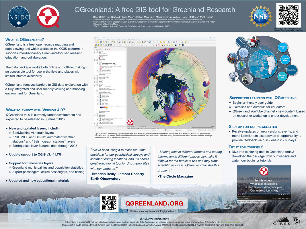
Accessing and interacting with interdisciplinary geospatial datasets is an ongoing challenge in the Earth Science community. QGreenland addresses this gap as a free, open-source mapping and data-viewing tool for Greenland, which works on the QGIS platform. By compiling diverse Greenland-focused datasets into an integrated GIS data package, QGreenland supports researchers and educators and promotes collaboration among the geoscience community and other interested groups.
Since 2019, QGreenland has been used by researchers and educators to plan field work, share maps and geospatial datasets, develop proposals and visuals, teach about Greenland and GIS, and has provided a foundational data environment for integrating new data. A variety of educational materials including the QGreenland website, user guide, and video tutorials make this data environment accessible for all user levels.
This poster provides an overview of QGreenland and highlights work on the upcoming v4 data package. V4 is expected to be released in 2026 and will include new and updated layers, improved support for QGIS v3.44 LTR, support for timeseries layers, and updated educational materials. Alpha releases are already underway and we welcome user engagement.
Poster
Learn more!
- QGreenland official site: learn about QGreenland, download the data package, and find teaching resources
- QGreenland on YouTube: find tutorial videos, workshop recordings, and more!
About the team
- Rikki Held
- Trey Stafford | GitHub
- Twila Moon
- Robyn Marowitz | GitHub
- Mariama Dryák-Vallies
- Sarah McGhee is a student at the University of Southern Maine
- Matt Fisher | GitHub